LogoDesktop@1LogoDesktopSticky@1LogoMobile@1LogoMobile@1
  • Locations
    • Europe
      • Austria
      • Belarus
      • Belgium
      • Bulgaria
      • Channel Islands
      • Croatia
      • Czech Republic
      • Denmark
      • Estonia
      • Finland
      • France
      • Germany
      • Greece
      • Hungary
      • Iceland
      • Ireland
      • Italy
      • Latvia
      • Lithuania
      • Luxembourg
      • Malta
      • Moldova
      • Montenegro
      • Netherlands
      • Norway
      • Poland
      • Portugal
      • Romania
      • Russia
      • Slovakia
      • Slovenia
      • Spain
      • Sweden
      • Switzerland
      • Ukraine
      • United Kingdom
    • Asia
      • Bangladesh
      • Cambodia
      • China
      • Georgia
      • India
      • Indonesia
      • Japan
      • Kazakhstan
      • Laos
      • Malaysia
      • Maldives
      • Nepal
      • Pakistan
      • Philippines
      • Singapore
      • South Korea
      • Taiwan
      • Thailand
      • Vietnam
    • North America
      • Bermuda
      • Canada
      • Mexico
      • United States of America
    • Middle East
      • Cyprus
      • Israel
      • Oman
      • Qatar
      • Turkey
      • United Arab Emirates
    • Africa
      • Ethiopia
      • Mauritius
      • Réunion
      • Senegal
      • Seychelles
      • South Africa
    • Caribbean
      • Greater Antilles
      • Lesser Antilles
    • Oceania
      • Australia
      • New Zealand
    • South America
      • Argentina
      • Bolivia
      • Brazil
      • Chile
      • Colombia
      • Ecuador
      • Paraguay
      • Peru
      • Uruguay
      • Venezuela
    • Central America
      • Belize
      • Costa Rica
      • Guatemala
    • Military
    • Helicopters
  • Preserved
  • News
  • Contact
    • Guide Update
    • Add a guide
    • Team
    • Contact
  • Useful
    • Plane Spotting – first steps
    • Tips & Tricks
    • FAQ
    • Links
  • Language
    • 中文
    • 日本人
    • русский
    • Français
    • Português
    • Español
    • Italiano
    • Deutsch
    • English
✕
  • Home
  • Locations North America United States of America
  • Oakland Intl. Airport – Spotting Guide

Oakland Intl. Airport – Spotting Guide

February 22, 2019 - last modified on November 30, 2023

Oakland International Airport (KOAK/OAK) is the San Francisco Bay Area’s smallest airport by passenger volume with around 13 million passengers passing through each year and serves the East Bay. The airport itself is located just south of Downtown Oakland and is adjacent to Bay Farm Island. Since the airport is situated in the bay, spotting angles are limited as only the eastern side of the commercial airport is accessible by land. The airport is split into two halves: the North Field, where all general aviation and corporate aviation operations take place, and the main commercial airport. The North Field contains three runways while the commercial airport has just one runway. Oakland is a major cargo hub for FedEx, serving over 20 destinations (two of which are Asian) thanks to a new facility built in 2013 to handle the 777 freighter. Oakland is also a focus city for Southwest Airlines, which takes up the majority of the market share at Oakland and also inhabit all of terminal 2. The North Field houses JetSuiteX’s operations and contains a base for Kaiser Air.

Although the majority of traffic in and out of Oakland is domestic, Oakland has seen the rapid expansion of international destinations due to explosion of budget carriers. Arekfly, Level, and British Airways all had unsuccessful attempts in making the Oakland market successful, but Norwegian and Azores Airlines (previously Sata Internacional) still serve a combined 7 transatlantic destinations. Volaris and Southwest Airlines serve a combined 6 Mexican destinations and Swoop will commence operations to Edmonton in May of 2019.

Oakland has been the base from which most Fleet week performers take off from since 2015. The arrival and departure of the Blue Angels draws massive crowds to the North Field and security around the North Field is generally more relaxed during Fleet week.

Written by Jordan Louie (local spotter). Last Update: January 2020

Rating
Movements
Airline Variety
Photo Locations
Weather
Airport Information
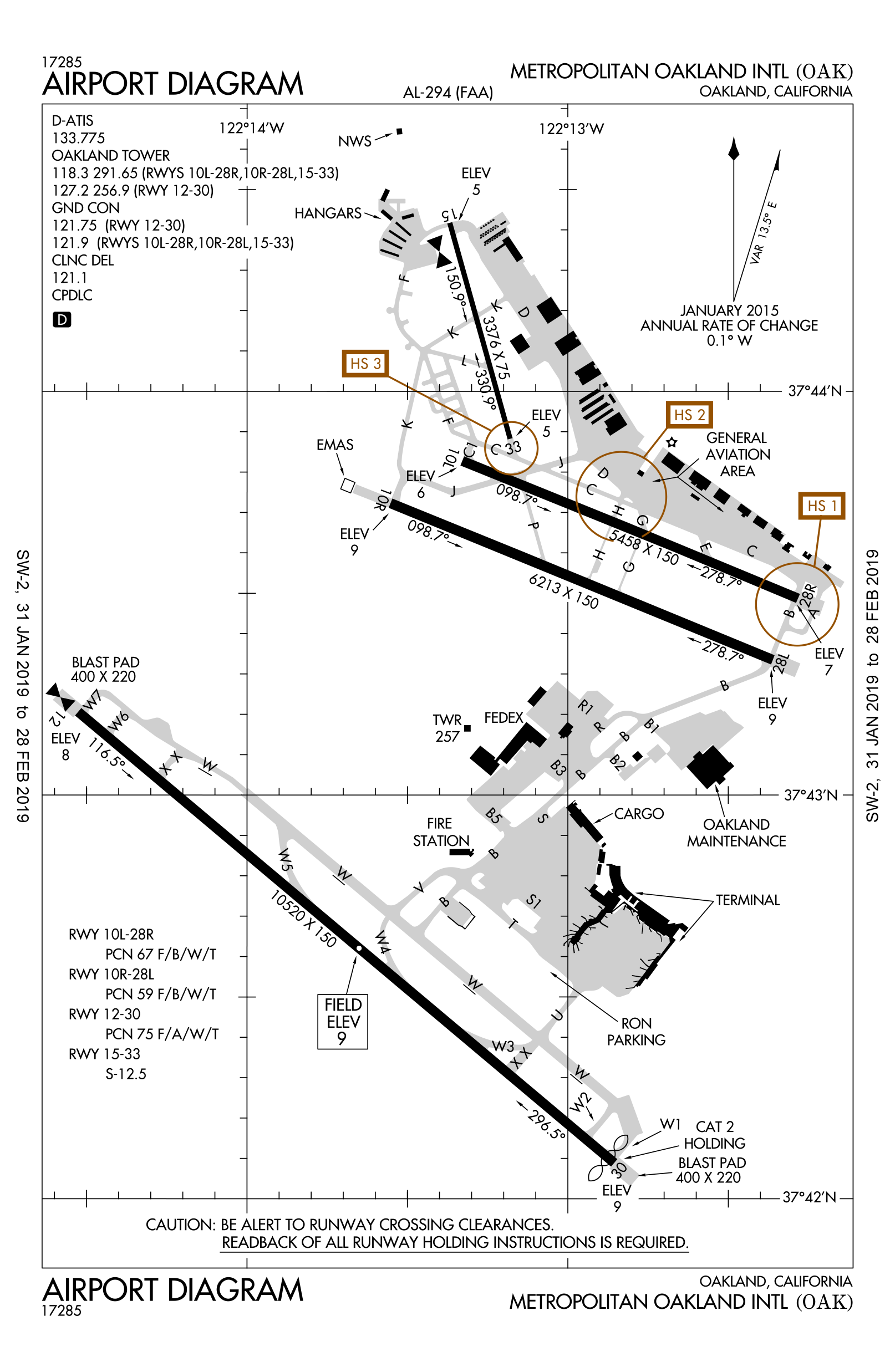
Runways
12/30 3.206 m (10.520 ft) asphalt
10R/28L 1.894 m (6.213 ft) asphalt
10L/28R 1.664 m (5.458 ft) asphalt
15/33 1.029 m (3.376 ft) asphalt
Terminals
Terminal 1 All carriers except Southwest
Terminal 2 Southwest Airlines only
Airport Chart
Spotting Information
Ladder Not needed (while it would be convenient to have a ladder at some North Field locations, it is highly discouraged due to security reasons)
Car/Public Transport There is no public transportation between spotting locations. A car is needed to access all spotting locations. Biking between spotting locations is also an option, as many locations are along the scenic Bay Trail (note that due to winds, biking north or west is significantly more difficult than biking south or east).
Restrooms In general, there are no bathrooms close to spotting locations. There are public restrooms available at the San Leandro Marina and Hayward Regional Shoreline, but not close to the spotting locations.
Drinks/Food There are no restaurants nearby.
Hotels The Hampton Inn and Suites on Bay Farm Island on located on Ron Cowan Parkway faces the end of Runway 30
Season Summer has the greatest variety of traffic. During winter, all locations that generally face westward are backlit.
Runway Usage
General Info Normal operations sees the use of runway 30 on the comercial airport side and runways 28L and 28R on the North Field. During reverse operations, runway 12 is used at the commercial airport and runways 10L and 10R are used on the North Field.
12/30 Major runway as its the longest and used for all comerical arrivals (except for JetSuiteX) and departures as well as all departures for business jets.
10R/28L Used by some general aviation and business jet arrivals and departures. General aviation working patterns and most Fleetweek performers also use this runway
10L/28R Used for the majority of business jet arrivals and all JetsuiteX arrivals. It is also used for most general aviation arrivals and departures.
15/33 33 is only used for general aviation departures. It isn’t a commonly used runway


Spot #1 – San Leandro Marina – Runway 30 arrivals
WHERE This is the most well-known location to spot at Oakland. To get here exit the I-880 freeway at Marina west (for both directions). Follow Marina Boulevard until you pass a blue sign that says San Leandro Marina with a sculpture of a bird below it. For more of a sideview, turn right on Mulford Point Drive and follow that road until it dead ends. There is a parking lot and small park at the end of the peninsula (1A). For more of a belly and side view, continue straight down Marina Boulevard (which turns into Monarch Bay Drive and follow it until you get to a roundabout. Enter the parking lot here (restrooms are here) and then walk or bike south on the Bay Trail, over the bridge and past the building with whales on it. Arrivals will be visible along this entire stretch of the trail, but the closest angle is a half a mile south of the parking lot at a bench on top of a small hill just before the trail turns east (1B).

If you are on bike and trying to get to Spot #2 (Hayward Regional Shoreline), follow the Bay Trail south. The trail will split at a housing development. Go right at this fork along the backyards of the houses. The trail will then turn west and then south again before transitioning to a gravel path. Follow this path south The third bridge (once you are on the gravel path) is one of the spotting locations at Spot #2. It is around 2 and a half miles between the spotting locations and around 5 miles from parking lot to parking lot.

If you are on bike and trying to head north towards the airport, you will need to head north on Monarch Bay Drive and the make a left onto Neptune Drive. Ride along Neptune Drive until it dead ends at Oyster Bay and then follow the Bay Trail north from here. It is about a 6 mile ride from the Marina Parking lot to the Hampton Inn parking lot.

WHAT This location is best for runway 30 arrivals.
TIME March to late October from sunrise to mid-morning is the best time to spot. Any other time is completely backlit.
MISC. At the first point the marina there are two restaurants and a hotel.
Restrooms are available at the parking/playground area as noted earlier. The only food here is the occasional ice cream truck.
FOCAL LENGTH 70-300mm is sufficient.

DSC_0692 1_01 1

OAK-Spot1A

DSC_0678 1_01 1

OAK-Spot1A

DSC03276 N605NK A320 232 Der Spirit Airlines NK359 Aus Las Vegas

OAK-Spot1A

DSC03260 N8571Z B737 8H4 Der Southwest Airlines WN1210 Aus Houston

OAK-Spot1A

DSC03271 N794SW B737 7H4 Der Southwest Airlines WN2332 Aus Minneapolis

OAK-Spot1A

DSC_0156 1

OAK-Spot1A


Spot #2 – Hayward Regional Shorline – Runway 30 arrivals
WHERE To get here, exit Winton Avenue West from the I-880 freeway and continue west on Winton Avenue past Hayward Executive Airport, through the railroad crossing, and straight through the four way stop. Continue past the industrial complex and make a left at the fork. Follow the road until you get to a gravel parking lot. Park here. If you have a lens with longer focal length and don’t feel like walking far, follow the path on the north side of the creek until you reach a dirt path that goes up a hill. On top of this hill is a possible spotting location and is only about a 3-5 minute walk from the parking lot (2A). A much closer angle is about a mile walk (15-20 minutes), or a 1.3-mile bike ride (5-10 minutes) out. If on foot, follow the dirt path up the hill and then make a left at the t-intersection. At the next intersection, walk straight through. At the third intersection, make a right and continue downhill to rejoin the main gravel path. Follow this gravel path north until you get to a bench just before a bridge. If you are on bike, bike down the paved path until you come to a t-intersection with a gravel path (the paved path is the thru path). Make a right onto the gravel path and bike north until you get to the bench at the first bridge.

If you are biking between spotting locations, follow the instructions above to get to and from the parking lot and the bridge. Then use the instructions from the San Leandro Marina section to get to the desired location. It is about a 5 mile ride to the San Leandro Marina and an 11 mile ride to the Hampton Inn (the ride is very scenic and a great form of exercise!).

WHAT This location is best for runway 30 arrivals
TIME Between March and late October, lighting is good from mid morning until sunset (Note the closer to winter, the earlier you can start spotting here). During the winter months, it is possible to spot here all day.
MISC. Outhouses are available at the paved parking lot at the very end of the road (past the gravel parking lot). There is no food here.
FOCAL LENGTH For the location on top of the hill around 250mm is needed for a 787 and around 400-500mm is needed for an A320 or 737. A 70-300mm lens is sufficient at the first bridge.
DSC_0557_01_01

OAK-Spot2A

DSC_0493_02

OAK-Spot2A

DSC_0073 1_01

OAK-Spot2A

ADSC_0817_01 1_01

OAK-Spot2A

ADSC_0628_01

OAK-Spot2A

DSC_0723 1_01

OAK-Spot2A

Spot #3 – Harbor Bay Parkway on Bay Farm Island – 30 departures 12 arrivals
WHERE From I-880 freeway, exit 98th Avenue and head west (if heading north make a left, and if heading south, make a right). Continue down 98th Avenue and watch for signs indicating Ron Cowan Parkway and Bay Farm Island. Exit the expressway to the right onto Ron Cowan Parkway. Continue under the bridge that connects the commercial airport to the North Field. To the right should be the North Field (obscured by bushes) and to the left should be the Bay Trail and the FedEx cargo terminal. Go straight through the intersection with the flagpoles (the street turns into Harbor Bay Parkway). Make a left into the Hampton Inn parking lot (the first chance to make a left after passing North Loop Road) and drive all the way to the back of the hotel which should face runway 30/12. If you look north, you should be able to see the Bay Bridge and the San Francisco skyline. From this spot behind the Hampton Inn parking lot, you will mainly get belly shots (3A). Heavy departures, however, will be much lower. An alternate location is across Harbor Bay Parkway on the grassy strip in front of The Waterfront business complex. You will still get many belly shots of Southwest planes from this location (3B). If you want a more side-angle, walk a block east to the grassy strip between North Loop Road and A street (3C).

If you are biking around this location, your main reference is the Bay Trail. It runs along Harbor Bay Parkway and Ron Cowan Parkway. Continuing south, you will cross John Glenn Drive and follow parallel to BART. At the next intersection, you can either make a 180 degree turn to continue south or continue along the trail to spot 28L/28R arrivals. From the Hampton Inn Parking lot, it is 1.5 miles to the cargo terminal, 2.75 miles to spot 28L/28R arrivals, 4.5 miles to Oyster Bay, 6 miles to the San Leandro Marina, and 11 miles to Hayward Regional Shoreline.

You can easily reach this spot from Downton San Francisco via the Ferry, exit is Harbor Bay Ferry Terminal, north of these spots.

WHAT This location is best for all runway 30 departures. Runway 12 arrivals are visible from the back of the Hampton Inn parking lot.
TIME March to late October from sunrise to mid-morning is the best time to spot. Any other time is completely backlit.
MISC. Please note that security does patrol this area frequently (even on weekends). I’ve never had any trouble spotting here, but I highly discourage tresspassing on private property to get closer to the runway (i.e. the back of the Frito Lay Distribution center)
FOCAL LENGTH 70-300mm is sufficient
Spot3A HA

Spot3A-HA

Spot3A SW

Spot3A-SW

Spot3B AS

Spot3B-AS

Spot3B NK

Spot3B-NK

Spot3C DL 1

Spot3C-DL

Spot3C WN

Spot3C-WN

Spot #4 – Cargo Terminal – FedEx Aircraft sitting on stands
WHERE This location is only accessible by bike on the Bay Trail. One option is to park at the Hampton Inn and bike south on the Bay Trail along Harbor Bay Parkway and Ron Cowan Parkway. Another option is to park at the Holiday Inn. Exit at 98th Avenue and head west. Make a left onto Airport Access Road and then a left into the Holiday Inn parking lot. Cross Doolittle Drive and follow the Bay Trail. Make a left to cross John Glenn Drive and then follow the Bay Trail along Ron Cowan Parkway. There are multiple possible angles along the cargo terminal.
WHAT FedEx parks a variety of aircraft at the stands that are visible (all except for the 777).
TIME The best time is morning, but since planes are parked in multiple positions and there are many angles along the Bay Trail, it is possible to spot here at any time.
MISC. There tends to be a lot of clutter in front of planes here. Security has never been an issue here, but do be aware that this bike path is frequently trafficked. Make sure that all of your possessions are off the trail so that other cyclists can get through. Since this location is along a trail that is along the side of a road, there are no bathrooms nor places to get food.
FOCAL LENGTH 20-200mm, depending on the position of aircraft
DSC 0040 1

OAK-Spot4

DSC 0034 1

OAK-Spot4

DSC 0042 1

OAK-Spot4

Spot #5 – Bay Trail along Metropolitan Golf Course – 28L/28R arrivals
WHERE This location is only accessible by bike or by foot on the Bay Trail (you cannot drive directly to this location with your car). One option is to park at the Hampton Inn and bike south on the Bay Trail along Harbor Bay Parkway and Ron Cowan Parkway. Cross John Glenn Avenue and then follow the Bay Trail until you get to the desired location. Another option is to park at the Holiday Inn. Exit at 98th Avenue and head west. Make a left onto Airport Access Road and then a left into the Holiday Inn parking lot. Cross Doolittle Drive and follow the Bay Trail until you get to the desired location. A final option where you can park on public property is Oyster Bay. Follow directions to the San Leandro Marina except make a right onto Neptune Drive from Marina Boulevard. Continue down Neptune Drive until it dead ends at Oyster Bay. The bike ride is about 2 miles. (Note that Oyster Bay is a possible spotting location, but the San Leandro Marina gets you significantly closer to planes and departures from runway 30 are slightly obscured by bushes and a seawall).
WHAT All arrivals for runway 28L/28R. Fleetweek performers will most commonly used 28L (this location is not well known so it will not be crowded).
TIME Since you can be on any side of the arrivals, lighting is fine all throughout the day.
MISC. There are no restrooms or food here. There are also no benches along the trail here. Security hasn’t been an issue
FOCAL LENGTH 70-300mm is sufficient, but wide angle lenses can be used if close enough.
DSC_0806_01

OAK-Spot5

Spot #6 – Center Median on Harbor Bay Parkway/Sidewalk along Harbor Bay Parkway – 28L/28R departures
WHERE From I-880 freeway, exit 98th Avenue and head west (if heading north make a left, and if heading south, make a right). Continue down 98th Avenue and make a right hand turn onto Airport Access Road. Make a left onto Hegenberger Avenue (another option is just to exit Hegenberger Avenue and then head south on Hegenberger) and then a right onto Doolittle Drive. Continue along Doolittle Drive down the entire length of the North Field and then make a left turn onto Harbor Bay Parkway. Park along Harbor Bay Parkway close to Maitland Drive on the side of the golf course. You can walk to position yourself depending on lighting and which runway is in use.

This location is extremely crowded during Fleetweek especially when the Blue Angels depart. J-walking onto the center median is common during Fleetweek, however is not recommended any other time of year.

WHAT All 28L/28R departures. Fleetweek performers will most commonly use 28L
TIME Since you can be on any side of the arrivals, lighting is fine all throughout the day.
MISC. There are no restrooms nor food here. Security has never been an issue, but again j-walking onto the center median is only encouraged during Fleetweek. If you are watching Fleetweek performers takeoff, it is highly recommended that you bring some sort of ear protection.
FOCAL LENGTH 70-300mm is sufficient, but wide angle lenses can be used if close enough.
DSC 0038

OAK-Spot6

DSC 0031

OAK-Spot6

DSC 0019

OAK-Spot6

Spot #7 – The North Field
WHERE From I-880 freeway, exit 98th Avenue and head west (if heading north make a left, and if heading south, make a right). Continue down 98th Avenue and make a right hand turn onto Airport Access Road. Make a left onto Hegenberger Avenue (another option is just to exit Hegenberger Avenue and then head south on Hegenberger) and then a right onto Doolittle Drive. Continue along Doolittle Drive and then make a left turn onto Swan Way. Make a left onto Earhart Road and park in the JetSuiteX lot. An alternative is to park at the Oakland Aviation Museum parking lot, in which you would make a right turn onto Earhart Road.
WHAT JetSuiteX, Kaiser air aircraft, miscellaneous charters, and corporate aircraft can all be photographed through chain-link fences. The Blue Angels will not park in a visible location anymore during Fleetweek, however C-130’s tend to park on the Kaiser Ramp
TIME Morning is best, but aircraft are parked in multiple positions.
MISC. Be quick when spotting here. Get your shot and leave as Alameda County Sheriff does often patrol the area. Do not hang around too long and do not bring a ladder. Security is more relaxed during Fleetweek, but it is still not wise to bring a ladder during this time.
FOCAL LENGTH A wide angle lens is best here.
DSC_0387_01

OAK-Spot7

DSC_0003_01

OAK-Spot7

DSCF0018 1_01

OAK-Spot7

Subscribe
Notify of
guest

guest

2 Comments
Newest
Oldest Most Voted
Trent Jaxson
Trent Jaxson
4 years ago

Love spot #3 considering how easy it is to get to! Not a local to Oakland but the ferry service between Downtown San Francisco – Harbor Bay makes this easily accessible without even using the crowded bay bridge. It is also by FAR the best spot to go to, especially when the planes land right in front of you during a period of reverse ops.

0
Reply
Julian
Julian
Admin
Reply to  Trent Jaxson
3 years ago

Good to know, thanks for the hint.
-Julian

0
Reply

Follow Us

Change Language

Latest articles

  • 0
    Stockholm Skavasta Nyköping Airport – Spotting Guide
    November 2, 2026
  • 0
    Palau Roman Tmetuchl Intl. Airport – Spotting Guide
    October 24, 2026
  • 0
    London Oxford Airport – Spotting Guide
    October 14, 2026
  • 0
    Montreal Metropolitan Saint-Hubert Airport – Spotting Guide
    October 4, 2026
  • 0
    Fuaʻamotu International Airport – Spotting Guide
    September 24, 2026

Recent Comments

  • November 5, 2026

    Nolan commented on Chicago O’hare Intl Airport – Spotting Guide

  • November 5, 2026

    Nolan commented on Chicago O’hare Intl Airport – Spotting Guide

  • November 5, 2026

    OMDB.yituoshi commented on Dubai International Airport – Spotting Guide

  • November 5, 2026

    OMDB.yituoshi commented on Dubai International Airport – Spotting Guide

  • November 4, 2026

    Ruud van Hoven commented on Toronto Pearson Intl. Airport – Spotting Guide

Spotting Guides

Europe
  • A Coruña LCG/LECO
  • Aasiaat JEG/BGAA
  • Aberdeen ABZ/EGPD
  • Ämari Air Base AMI/EEEI
  • Ajaccio AJA/LFKJ
  • Akureyri AEY/BIAR
  • Albacete Air Base ABC/LEAB
  • Ålesund Vigra AES/ENAL
  • Alicante ALC/LEAL
  • Altenrhein-St.Gallen ACH/LSZR
  • Amsterdam Schiphol AMS/EHAM
  • Ancona AOI/LIPY
  • Antwerp ANR/EBAW
  • Athens ATH/LGAV
  • Augsburg Mühlhausen AGB/EDMA
  • Aviano Air Base AVB/LIPA
  • Barcelona El Prat BCN/LEBL
  • Bari BRI/LIBD
  • Basel Mulhouse Freiburg BSL/LFSB
  • Bastia Poretta BIA/LFKB
  • Beja BYJ/LPBJ
  • Berlin Brandenburg BER/EDDB
  • Belfast City BHD/EGAC
  • Belgrade BEG/LYBE
  • Bergen Flesland BGO/ENBR
  • Bern-Belp BRN/LSMB/LSZB
  • Bilbao BIO/LEBB
  • Billund BLL/EKBI
  • Birmingham BHX/EGBB
  • Blackpool BLK/EGNH
  • Bologna BLG/LIPE
  • Bordeaux BOD/LFBD
  • Bournemouth BOH/EGHH
  • Bratislava BTS/LZIB
  • Braunschweig BWE/EDVE
  • Bremen BRE/EDDW
  • Brescia VBS/LIPO
  • Brest Bretagne BES/LFRB
  • Brindisi Casale BDS/LIBR
  • Bristol BRS/EGGD
  • Brize Norton-BZZ/EGVN
  • Brussels BRU/EBBR
  • Brussels Charleroi CRL/EBCI
  • Bucharest Henri Coanda OTP/LROP
  • Budapest BUD/LHBP
  • Buochs BXO/LSZC
  • Bydgoszcz BZG/EPBY
  • Cameri AFB LIMN
  • Caen Carpiquet CFR/LFRK
  • Cagliari CAG/LIEE
  • Calvi CLY/LFKC
  • Cascais Tejo CAT/LPCS
  • Cardiff CWL/EGFF
  • Catania Fontanarossa CTA/LICC
  • Chambéry Savoie CMF/LFLB
  • Châteauroux-Centre CHR/LFLX
  • Cherbourg CER/LFRC
  • Chisinau KIV/LUKK
  • Ciudad Real CQM/LERL
  • Cluj Avram Iancu CLJ/LRCL
  • Cologne/Bonn CGN/EDDK
  • Coningsby QCY/EGXC
  • Copenhagen Kastrup CPH/EKCH
  • Corfu CFU/LGKR
  • Cotswold Kemble GBA/EGBP
  • Courchevel Alitport CVF/LFJL
  • Cranfield XUD/EGTC
  • Den Helder DHR/EHKD
  • Dinard Saint Malo DNR/LFRD
  • Dortmund DTM/EDLW
  • Dresden DRS/EDDC
  • Dublin DUB/EIDW
  • Dübendorf LSMD
  • Düsseldorf DUS/EDDL
  • East Midlands EMA/EGNX
  • Edinburgh EDI/EGPH
  • Eindhoven EIN/EHEH
  • Emmen EML/LSME
  • Engadin/Samedan SMV/LSZS
  • Enschede Twente ENS/EHTW
  • Erfurt-Weimar ERF/EDDE
  • Exeter EXT(EGTE
  • RAF Fairford FFD/EGVA
  • Faro FAO/LPFR
  • Farnborough FAB/EGLF
  • Florence FLR/LIRQ
  • Florennes Air Base EBFS
  • Forlì Luigi Ridolfi FRL/LIPK
  • Frankfurt Rhein/Main FRA/EDDF
  • Frankfurt Hahn HHN/EDFH
  • Friedrichshafen FDH/EDNY
  • Funchal Madeira FNC/LPMA
  • Fuerteventura FUE/GCFV
  • Gdańsk Lech Wałęsa GDN/EPGD
  • Geilenkirchen NATO Base GKE/ETNG
  • Geneva GVA/LSGG
  • Genoa GOA/LIMJ
  • Getafe Air Base LEGT
  • Gibraltar GIB/LXGB
  • Gilze-Rijen Air Base EHGR
  • Girona Costa Brava GRO/LEGE
  • Glasgow GLA/EGPF
  • Glasgow-Prestwick PIK/EGPK
  • Gothenburg Landvetter GOT/ESGG
  • Gran Canara LPA/GCLP
  • Granada-Jaén GRX/LEGR
  • Graz GRZ/LOWG
  • Grenchen LSZG
  • Greonble Isère GNB/LFLS
  • Groningen GRQ/EHGG
  • Guernsey GCI/EGJB
  • Győr Pér OGY/LHPR
  • Hamburg Finkenwerder XFW/EDHI
  • Hamburg Fuhlsbuettel HAM/EDDH
  • Hannover HAJ/EDDV
  • Helsinki HEL/EFHK
  • Heraklion HER/LGIR
  • Hohn Air Base ETNH
  • Humberside HUY/EGNJ
  • Ibiza IBZ/LEIB
  • Ingolstadt Manching IGS/ETSI
  • Innsbruck INN/LOWI
  • Inverness INV/EGPE
  • Ireland West Knock NOC/EIKN
  • Istrana Air Base LIPS
  • Izhevsk IJK/USII
  • Jagel Schleswig Air Base WBG/ETNS
  • Jersey JER/EGJJ
  • Karlsruhe FKB/EDSB
  • Kassel Calden KSF/EDVK
  • Katowice KTW/EPKT
  • Kecskemet Air Base LHKE
  • Kefalonia EFL/LGKF
  • Keflavik KEF/BIKF
  • Kiev Boryspil KBP/UKBB
  • Kiev Zhuliany LEV/UKKK
  • Kleine Brogel EBBL
  • Kos KGS/LGKO
  • Kraków KRK/EPKK
  • La Palma SPC/GCLA
  • Lausanne Blécherette LSGL
  • Lahr LHA/EDTL
  • Lakeneath RAF Base LKZ/EGUL
  • Lamezia Terme SUF/LICA
  • Lands End LEQ/EGHC
  • Landivisiau Air Base LFRJ
  • Lanzarote-Arrecife ACE/GCRR
  • Lajes Base 4 TER/LPLA
  • Leipzig/Halle LEJ/EDDP
  • Leeuwarden Air Base LWR/EHLW
  • Liège Bierset LGG/EBLG
  • Linz LNZ/LOWL
  • Lisbon Portela LIS/LPPT
  • Ljubljana LJU/LJLJ
  • London Biggin Hill BQH/EGKB
  • London City LCY/EGLC
  • London Gatwick LGW/EGKK
  • London Heathrow LHR/EGLL
  • London Luton LTN/EGGW
  • London Southend SEN/EGMC
  • London Stansted STN/EGSS
  • Lorient-Lann-Bihoué LRT/LFRH
  • Lossiemouth RMO/EGQS
  • Luxembourg Findel LUX/ELLX
  • Lyon Saint Exupéry LYS/LFLL
  • Maastricht/Aachen MST/EHBK
  • Mach Loop LFA7
  • Madrid Barajas MAD/LEMD
  • Malaga AGP/LEMG
  • Malmö MMX/ESMS
  • Malta Luqa MLA/LMML
  • Manchester MAN/EGCC
  • Marseille MRS/LFML
  • Meiringen AFB LSMM
  • Memmingen FMM/EDJA
  • Milan Bergamo BGY/LIME
  • Milan Linate LIN/LIML
  • Milan Malpensa MXP/LIMC
  • Mildenhall RAF Base MHZ/EGUN
  • Milos MLO/LGML
  • Minsk MSQ/UMMS
  • Moenchengladbach MGL/EDLN
  • Montpellier Méditerranée Airport MPL/LFMT
  • Morlaix-Ploujean MNX/LFRU
  • Moscow Domodedovo DME/UUDD
  • Moscow Sheremetyevo SVO/UUEE
  • Moscow Vnukovo VKO/UUWW
  • Munich Franz J. Strauss MUC/EDDM
  • Münster/Osnabrück FMO/EDDG
  • Mykonos JMK/LGMK
  • Nantes Atlantique NTE/LFRS
  • Naples NAP/LIRN
  • Naxos JNX/LGNX
  • Neuburg Fliegerhorst ETSN
  • Newcastle NCL/EGNT
  • Nice Côte d’Azur NCE/LFMN
  • Nîmes FNI/LFTW
  • Novosibirsk Tolmachevo OVB/UNNT
  • Nordholz Cuxhaven FCN/ETMN
  • Nörvenich QOE/ETNN
  • Norwich NWI/EGSH
  • Nuremberg NUE/EDDN
  • Orange-Caritat Air Base 115 LFMO
  • Orléans Bricy Air Base LFOJ
  • Oslo Gardemoen OSL/ENGM
  • Ostend-Bruges OST/EBOS
  • Paderborn-Lippstadt PAD/EDLP
  • Palma de Mallorca PMI/LEPA
  • Palermo PMO/LICJ
  • Pardubice PED/LKPD
  • Paris Charles de Gaulle CDG/LFPG
  • Paris Le Bourget LGB/LFPB
  • Paris Orly ORY/LFPO
  • Paris Vatry XCR/LFOK
  • Parma PMF/LIMP
  • Payerne AFB-LSMP
  • Perpignan PGF/LFMP
  • Pescara PSR/LIBP
  • Pisa PSA/LIRP
  • Ponta Delgada PDL/LPPD
  • Porto OPO/LPPR
  • Poznan POZ/EPPO
  • Prague Václav Havel PRG/LKPR
  • Pratica die Mare Air Base LIRE
  • Pula PUY/LDPL
  • RAF Valley Anglesey VLY/EGOV
  • Ramstein Air Base RMS/ETAR
  • Rennes Saint-Jacques RNS/LFRN
  • Reykjavik RKV/BIRK
  • Rhodes Diagoras RHO/LGRP
  • Riga Skulte RIX/EVRA
  • Rimini RMI/LIPR
  • Rome Ciampino CIA/LIRA
  • Rome Fiumicino FCO/LIRF
  • Rotterdam RTM/EHRD
  • Salerno Costa D’Amalfi QSR/LIRI
  • Salzburg W.A. Mozart SZG/LOWS
  • Samos SMI/LGSM
  • San Sebastinán EAS/LESO
  • Sandefjord TRJ/ENTO
  • Santorini JTR/LGSR
  • Sevilla SVQ/LEZL
  • Shannon SNN/EINN
  • Sion SIR/LSGS-LSMS
  • Skiathos JSI/LGSK
  • Sibiu SBZ/LRSB
  • Sofia SOF/LBSF
  • Southampton SOU/EGHI
  • Spangdahlem Air Base SPM/ETAD
  • Split SPU/LDSP
  • St. Athan DGX/EGSY
  • St. Petersburg Pulkovo LED/ULLI
  • Stavanger SVG/ENZV
  • Stockholm Arlanda ARN/ESSA
  • Stockholm Bromma BMA/ESSB
  • Strasbourg SXB/LFST
  • Stuttgart Echterdingen STR/EDDS
  • Svolvær Helle SVJ/ENSH
  • Sylt Westerland GWT/EDXW
  • Szczecin Goleniów SZZ/EPSC
  • Tallinn TLL/EETN
  • Taranto TAR/LIBG
  • Tarbes-Lourdes TLP/LFBT
  • Teesside MME/EGNV
  • Tenerife North TFN/GCXO
  • Tenerife South TFS/GCTS
  • Teruel TEV/LETL
  • Thessaloniki SKG/LGTS
  • Tivat TIV/LYTV
  • Torrejón TOJ/LETO
  • Toulouse Blagnac TLS/LFBO
  • Toulouse Francazal LFBF
  • Tours Val de Loire TUF/LFOT
  • Trento LIDT
  • Treviso TSF/LIPH
  • Trieste TRS/LIPQ
  • Tromsø TSO/ENTC
  • Trondheim TRD/ENVA
  • Turin TRN/LIMF
  • Ulyanovsk Baratayevka ULV/UWLL
  • Valencia VLC/LEVC
  • Venice VCE/LIPZ
  • Verona Villafranca VRN/LIPX
  • Vienna Schwechat VIE/LOWW
  • Vigo Peinador VGO/LEVX
  • Vilnius VNO/EYVI
  • Volkel Air Base EHVK
  • RAF Waddington
  • Warsaw Chopin WAW/EPWA
  • Weeze NRN/EDLV
  • Wiesbaden Erbenheim WIE/ETOU
  • Woensdrecht Air Base WOE/EHWO
  • Wroclaw WRO/EPWR
  • Wunstorf Fliegerhorst ETNW
  • Zadar ZAD/LDZD
  • Zakynthos ZTH/LGZA
  • Zaragoza ZAZ/LEZG
  • Zeltweg Air Base LOXZ
  • Zürich Kloten ZRH/LSZH
Middle East
  • Abu Dhabi AUH/OMAA
  • Antalya AYT/LTAI
  • Dubai Intl. Airport DXB/OMDB
  • Doha Hamad DOH/OTHH
  • Dubai World Central DWC/OMDW
  • Istanbul IST/LTFM
  • Istanbul Atatürk ISL/LTBA
  • Istanbul Sabiha Gökçe SAW/LTFJ
  • Izmir Adnan Menderes ADB/LTBJ
  • Kuwait KWI/OKKK
  • Larnaca Airport LCA/LCLK
  • Muscat MCT/OOMS
  • Ras al Khaimah RKT/OMRK
  • Sharjah Intl. Airport SHJ/OMSJ
  • Tel-Aviv Ben Gurion TLV/LLBG
Asia
  • Almaty ALA/UAAA
  • Balikpapan SAMS Sepinggan BPN/WALL
  • Bangkok Suvarnabhumi BKK/VTBS
  • Bangkok Don Muang DMK/VTBD
  • Beijing Capital PEK/ZBAA
  • Cebu (Mactan) CEB/RPVM
  • Chengdu Shuangliu CTU/ZUUU
  • Cochin COK/VOCI
  • Delhi Indira Ghandi DEL/VIDP
  • Denpasar Ngurah Rai DPS/WADD
  • Dhaka Hazrat Shahjalal DAC/VGZR
  • Fukuoka FUK/RJFF
  • Gifu Air Base QGU/RJNG
  • Gimhae PUS/RKPK
  • Guangzhou-Baiyun CAN/ZGGG
  • Hanoi Nội Bà HAN/VVNB
  • Ho Chi Minh City-Saigon SGN/VVTS
  • Hong Kong HKG/VHHH
  • Ibaraki-Hyakuri IBR/RJAH
  • Iruma Air Base RJTJ
  • Islamabad ISB/OPIS
  • Jakarta Halim Perdanakusuma HLP/WHHH
  • Jakarta Soekarno-Hatta CGK/WIII
  • Kadena AFB DNA/RODN
  • Karachi KHI/OPKC
  • Kathmandu Tribhuvan KTM/VNKT
  • Koh Samui USM/VTSM
  • Kota Kinabalu BKI/WBKK
  • Kuala Lumpur KUL/WMKK
  • Lahore LHE/OPLA
  • Langkawi LGK/WMKL
  • Lukla Tenzing Hillary LUA/VNLK
  • Macau MFM/VMMC
  • Medan Kualanamu KNO/WIMM
  • Miyako MMY/ROMY
  • Mumbai BOM/VABB
  • Nagoya Chubu Centrair NGO/RJGG
  • Nagoya Komaki NKM/RJNA
  • Nanjing NKG/ZSNJ
  • New Chitose Sapporo CTS/RJCC
  • Okinawa Naha OKA/ROAH
  • Osaka Itami ITM/RJOO
  • Osaka Kansai Intl. Airport KIX/RJBB
  • Phú Quốc PQC/VVPQ
  • Phuket HKT/VTSP
  • Radin Inten II TKG/WILL
  • Samarinda Aji Pangeran AAP/WALS
  • Sanya Phoenix SYX/ZJSY
  • Seoul Incheon Airport ICN/RKSI
  • Seoul Gimpo Airport GMP/RKSS
  • Shanghai Hongqiao SHA/ZSSS
  • Shanghai Pudong PVG/ZSPD
  • Shizuoka FSZ/RJNS
  • Siem Reap REP/VDSR
  • Singapore Changi SIN/WSSS
  • Singapore Seletar XSP/WSSL
  • Surat STV/VASU
  • Subang Intl. Airport SZB/WMSA
  • Taipei Taoyuan TPE/RCTP
  • Tashkent TAS/UZTT
  • Tbilisi TBS/UGTB
  • Taiyuan Wusu TYN/ZBYN
  • Tianjin Binhai TSN/ZBTJ
  • Trivandrum TRV/VOTV
  • Tokyo Haneda HND/RJTT
  • Tokyo Narita NRT/RJAA
  • Ulaanbaatar UBN/ZMCK
  • Velena Male MLE/VRMM
  • Wuhan Tianhe WUH/ZHHH
  • Xiamen Gaoqi XMN/ZSAM
  • Yerevan Zvartnots EVN/UDYZ
  • Yogyakarta Adisucipto YOG/WAHH
  • Zhengzhou Xinzheng CGO/ZHCC
North America
  • Aasiaat JEG/BGAA
  • Albany ALB/KALB
  • Albuquerque ABQ/KABQ
  • Altus AFB LTS/KLTS
  • Anchorage Ted Stevens ANC/PANC
  • Aspen Pitkin County ASE/KASE
  • Atlanta Hartsfield-Jackson ATL/KATL
  • Austin Bergstrom AUS/KAUS
  • Baltimore BWI/KBWI
  • Bangor BGR/KBGR
  • Barksdale AFB BAD/KBAD
  • Bemidji BJI/BJI
  • Bentonville XNA/KXNA
  • Bermuda BDA/TXKF
  • Birmingham Shuttlesworth BHM/KBHM
  • Boca Raton BCT/KBCT
  • Boise BOI/KBOI
  • Boston Logan BOS/KBOS
  • Bozeman Yellowstone BZN/KBZN
  • Brunswick Golden Isles BQK/KBQK
  • Buffalo Niagara BUF/KBUF
  • Burbank Hollywood BUR/KBUR
  • Calgary YYC/CYYC
  • Cancun CUN/MMUN
  • Charleston CHS/KCHS
  • Charlotte Douglas CLT/KCLT
  • Chicago Midway MDW/KMDW
  • Chicago O´Hare ORD/KORD
  • Cincinnati Northern Kentucky CVG/KCVG
  • Cleveland Hopkins CLE/KCLE
  • College Station Easterwood CLL/KCLL
  • Columbia CAE/KCAE
  • Columbus, Ohio CMH/KCMH
  • Comox Valley YQQ/CYQQ
  • Concord Buchanan CCR/KCCR
  • Culiacán CUL/MMCL
  • Dallas Addison ADS/KADS
  • Dallas Fort Worth DFW/KDFW
  • Dallas Love Field DAL/KDAL
  • Davis Monthan Air Base DMA/KDMA
  • Daytona Beach DAB/KDAB
  • DeKalb-Peachtree PDK/KPDK
  • Denver DEN/KDEN
  • Des Moines DSM/KSDM
  • Detroit Metropolitan DTW/KDTW
  • Detroit Willow Run YIP/KYIP
  • Dover Air Base DOV/KDOV
  • Dyess AFB DYS/KDYS
  • Eagle County EGE/KEGE
  • Edmonton YEG/CYEG
  • El Paso ELP/KELP
  • Elizabeth City CGAS ECG/KECG
  • Fargo FAR/KFAR
  • Fort Lauderdale FLL/KFLL
  • Fort Lauderdale Executive FXE/KFXE
  • Fort Worth Alliance AFW/KAFW
  • Fort Worth NAS JRB NFW/KNFW
  • Gander YQX/CYQX
  • Grand Canyon National Park GCN/KGCN
  • Grand Junction GJT/KGJT
  • Greensboro Piedmont Triad GSO/KGSO
  • Hamilton YHM/CYHM
  • Hartford/Bradley BDL/KBDL
  • Honolulu HNL/PHNL
  • Houston George Bush IAH/KIAH
  • Houston Hobby HOU/KHOU
  • Indianapolis IND/KIND
  • John Wayne Orange County SNA/KSNA
  • Kamloops YKA/CYKA
  • Kangerlussuaq SFJ/BGSF
  • Kansas City MCI/KMCI
  • Kelowna YLW/CYLW
  • Key West EYW/KEYW
  • King County/Boeing Field BFI/KBFI
  • Kingman IGM/KIGM
  • Knoxville TYS/KTYS
  • Kona Keahole KOA/PHKO
  • Lake Hood Seaplane Base LHD/PALH
  • Langley AFB LFI/KLFI
  • Laredo LRD/KLRD
  • Las Vegas McCarran LAS/KLAS
  • Latrobe LBE/KLBE
  • Lehigh Valley ABE/KABE
  • Lexington LEX/KLEX
  • Lihue LIH/PHLI
  • Long Beach LGB/KLGB
  • Los Angeles LAX/KLAX
  • Louisville SDF/KSDF
  • Luke AFB LUF/KLUF
  • Madison Dane County MSN/KMSN
  • Madras Municipal MDJ
  • Manchester Boston MHT/KMHT
  • Marana Pinal Airpark MZJ/KMZJ
  • March Air Reserve Base RIV/KRIV
  • Memphis MEM/KMEM
  • Mexico City MEX/AICM
  • Miami MIA/KMIA
  • Milwaukee Mitchell MKE/KMKE
  • Minneapolis-Saint Paul MSP/KMSP
  • Montréal Mirabel YMX/CYMX
  • Montréal–Pierre Elliott Trud. YUL/CYUL
  • Myrtle Beach MYR/KMYR
  • Nanaimo YCD/CYCD
  • Naples APF/KAPF
  • Nashville BNA/KBNA
  • Naval Air Facility El Centro NJK/KNJK
  • Nellis Air Base LSV/KLSV
  • Newark Liberty EWR/KEWR
  • New Orleans MSY/KMSY
  • New York West 30th St Heliport JRA/KJRA
  • New York John F. Kennedy JFK/KFJK
  • New York La Guardia LGA/KLGA
  • New York Stewart SWF/KSWF
  • Norfolk ORF/KORF
  • Norfolk Chambers NAS NGU/KNGU
  • Nuuk GOH/BGGH
  • Oakland OAK/KOAK
  • Ogden Hinckley OGD/KOGD
  • Oklahoma City OKC/KOKC
  • Omaha Eppley OMA/KOMA
  • Ontario ONT/KONT
  • Orlando MCO/KMCO
  • Ottawa YOW/CYOW
  • Page Municipal PGA/KPGA
  • Paine Field PAE/KPAE
  • Palm Springs PSP/KPSP
  • Palm Beach PBI/KPBI
  • Pensacola PNS/KPNS
  • Philadelphia PHL/KPHL
  • Phoenix Deer Valley DVT/KDVT
  • Phoenix Goodyear GYR/KGYR
  • Phoenix Mesa AZA/KIWA
  • Phoenix Sky Harbour PHX/KPHX
  • Piedmont Triad GSO/KGSO
  • Pittsburgh PIT/KPIT
  • Portland,OR PDX/KPDX
  • Portsmouth PSM/KPSM
  • Provo Municipal PVU/KPVU
  • Providence T.F. Green PVD/KPVD
  • Punta Gorda PGD/KPGD
  • Québec Jean-Lesage YQB/CYQB
  • Rainbow Canyon R-2508
  • Raleigh-Durham RDU/KRDU
  • Redmond RDM/KRDM
  • Renton RNT/KRNT
  • Richmond RIC/KRIC
  • Roanoke-Blacksburg ROA/KROA
  • Sacramento SMF/KSMF
  • Sacramento Mather MHR/KMHR
  • Sacramento McClellan MCC/KMCC
  • Salt Lake City SLC/KSLC
  • San Antonio SAT/KSAT
  • San Antonio Lackland SKF/KSKF
  • San Bernadino SBD/KSBD
  • San Diego SAN/KSAN
  • San Diego Brown Field SDM/KSDM
  • San Diego North Island NAS KNZY
  • San Francisco SFO/KSFO
  • San José Norman Y. Mineta SJC/KSJC
  • San Luis Obispo SBP/KSBP
  • Santa Barbara SBA/KSBA
  • Sarasota Bradenton SRQ/KSRQ
  • Savannah Hilton Head SAV/KSAV
  • Scottsdale SCF/KSDL
  • Seattle Tacoma SEA/KSEA
  • Southwest Florida Fort Myers RSW/KRSW
  • Spokane GEG/KGEG
  • St. George SGU/KSGU
  • St. Louis Lamber STL/KSTL
  • St. Pete Clearwater PIE/KPIE
  • Syracuse Hancock SYR/KSYR
  • Tampa TPA/KTPA
  • Tampico TMA/MMTM
  • Teterboro TEB/KTEB
  • Toluca TLC/MMTO
  • Toronto Island YTZ/CYTZ
  • Toronto Pearson YYZ/CYYZ
  • Trenton Mercer TTN/KTTN
  • Trenton CFB YTR/CYTR
  • Tucson TUS/KTUS
  • Tweed New Haven HVN/KHVN
  • Val d’Or YVO/CYVO
  • Van Nuys VNY/KVNY
  • Vancouver/Seaplane YVR/CYVR/CAM9
  • Vancouver Harbour Flight Centre CXH/CYHC
  • Victoria YYJ/CYYJ
  • Victoria Inner Harbour YWH/CYWH
  • Victorville Southern California VCV/KVCV
  • Waco TSTC CNW/KCNW
  • Waco Regional ACT/KACT
  • Washington Dulles IAD/KIAD
  • Washington R. Reagan DCA/KDCA
  • Waterbury Oxford OXC/KOXC
  • Whitehorse Erik Nielsen YXY/CYXY
  • Yellowknife YZF/CYZF/CEN9

South America

  • Asunción ASU/SGAS
  • Belo Horizonte-Confins CNF/SBCF
  • Boa Vista BVB/SBBV
  • Bogota El Dorado BOG/SKBO
  • Brasília BSB/SBBR
  • Buenos Aires Aeroparque AEP/SABE
  • Buenos Aires Ministro Pistarini EZE/SAEZ
  • Caracas Simon Bolivar CCS/SVMI
  • Cascavel CAC/SBCA
  • Cuiabá Marechal Rondon CGB/SBCY
  • Curitiba Alfonso Pena CWB/SBCT
  • Curitiba Bacacheri BFH/SBBI
  • Cusco CUZ/SPZO
  • El Calafate FCE/SAWC
  • Florianópolis FLN/SBFL
  • Fortaleza Pinto Martins FOR/SBFZ
  • Foz do Iguaçu IGU/SBFI
  • Guayaquil GYE/SEGU
  • Jundiaí GDV/SBJD
  • La Paz El Alto LPB/SLLP
  • Lima LIM/SPJC
  • Londrina LDB/SBLO
  • Macaé MAE/SBME
  • Manaus BAO/SBEG
  • Maringá MGF/SBMG
  • Medellin Cordova MDE/SKRG
  • Medellin Olaya Herrera EOH/SKMD
  • Montevideo MVD/SUMU
  • Navegantes NVT/SBNF
  • Porto Alegre POA/SBPA
  • Porto Seguro BPS/SBPS
  • Quito Mariscal Sucre UIO/SEQM
  • Rio, Galeão GIG/SBGL
  • Rio, Santos Dumont SDU/SBRJ
  • Salvador SSA/SBSV
  • San Carlos de Bariloche BRC/SACS
  • Santiago de Chile SCL/SCEL
  • Sao Paulo Campo de Marte RTE/SBMT
  • Sao Paulo Congonhas CGH/SBSP
  • Sao Paulo Guarulhos GRU/SBGR
  • Teresina THE/SBTE
  • Ushuaia USH/SAWH
  • Viracopos Campinas VCP/SBKP
Central America
  • Belize Municipal TZA/MZBE
  • Guatemala City GUA/MGGT
  • Panama City PTY/MPTO
  • San Jose SJO/MROC
  • San Pedro SPR/MZSP
Oceania
  • Auckland Intl. Airport AKL/NZAA
  • Adelaide ADL/YPAD
  • Avalon AVV/YMAV
  • Bankstown BWU/YSBK
  • Brisbane BNE/YBBN
  • Broome BME/YBRM
  • Canberra CBR/YSCB
  • Carnarvon CVQ/YCAR
  • Christchurch Intl. Airport CHC/NZCH
  • Darwin DRW/YPDN
  • Gold Coast OOL/YBCG
  • Jandakot JAD/YPIT
  • Melbourne MEL/YMML
  • Melbourne Essendon
  • Moorabbin MBW/YMMB
  • Moorea Temaea MOZ/NTTM
  • Nadi NAN/NFFN
  • Napier Hawke's Bay NPE/NZNR
  • Nelson NSN/NZNS
  • Nowra Air Station NOA/YSNW
  • Papeete PPT/NTAA
  • Perth PER/YPPH
  • Queenstown ZQN/NZQN
  • Rarotonga Intl. Airport RAR/NCRG
  • Richmond RAAF XRH/YSRI
  • Sydney Kingsford Smith SYD/YSSY
  • Wellington WLG/NZWN
Caribbean
  • Antigua V.C. Bird ANU/TAPA
  • Aruba Queen Beatrix AUA/TNCA
  • Barbados Grantley Adams BGL/TBPB
  • Bonaire BON/TNCB
  • Castries St. Lucia SLU/TLPC
  • Curaçao Hato CUR/TNCC
  • Fort de France FDF/TFFF
  • George Town GCM/MWCR
  • Grand Bahama Freeport FPO/MYGF
  • Kingston Norman Manley KIN/MKJP
  • Pointe-à-Pitre PTP/TFFR
  • Port of Spain Piarco POS/TTPP
  • Saint Barthélemy SBH/TFFJ
  • San Juan Luis Muñoz SJU/TJSJ
  • Saint Thomas Cyril E. King STT/TIST
  • Sint Maarten SXM/TNCM
Africa
  • Antananarivo TNR/FMMI
  • Cape Town CPT/FACT
  • Dakar DSS/GOBD
  • Durban DUR/FALE
  • Fort Dauphin FTU/FMSD
  • Johannesburg O.R. Tambo JNB/FAOR
  • Lanseria HLA/FALA
  • Mauritius MRU/FIMP
  • Nairobi NBO/HKJK
  • Nairobi Wilson WIL/HKNW
  • Port Elizabeth PLZ/FAPE
  • Parslin PRI/FSPP
  • Pretoria Waterkloof WKF/FAWK
  • Saint Denis RUN/FMEE
  • Saint-Pierre Pierrefonds ZSE/FMEP
  • Seychelles SEY/FSIA
  • Tunis Carthage TUN/DTTA
  • Windhoek Eros ERS/FYWE
  • Zanzibar ZNZ/HTZA
© 2026 spotterguide.net   |   copyright & privacy policy   |   contact
wpDiscuz

No Google Maps embed found on this page.

For information only. Always verify NOTAMs using official aeronautical sources. FAA NOTAM Search

—
12:00
Sunrise—|—Sun position—|—|—Sunset—|—
Loading airport map…
Sunrise—
Sunset—
Azimuth—
Sun altitude—
Golden hour—

Times are shown in the airport’s local time when timezone detection is available. The numbered spotting locations are shown for reference only; they do not change the sun calculation. Drag the main marker to choose the runway or target point. Solar calculations are approximate; based on SunCalc by Vladimir Agafonkin. Map imagery © Esri and contributors.